
The Ecological Regions of Kentucky
- Zac Gnadinger
- Feb 13, 2023
- 8 min read
Updated: Sep 4, 2025

Kentucky is rich in natural beauty and diversity, with multiple ecological regions that support various plant and animal species.
Because of this diversity, knowing your ecological region is essential when selecting native plants for your property. Otherwise, you might choose plants that aren't native to your area.
In this article, we'll explore the five ecological regions of Kentucky so you can confidently select native plants well-suited for your local environment.
Let's get started.
Disclaimer:
The diagrams used in this article are simplified, grouping areas based on the typical distribution of native plants. In actuality, Kentucky contains 25 ecoregions. For more information, please visit the USEPA's level IV ecological assessment.
What Are Ecological Regions?
Ecological regions, or ecoregions, are large areas of land and water that share similar physical and biological characteristics, such as climate, soil, vegetation, and wildlife.
They are used to study and understand the relationships between plants, animals, and the environment and help guide conservation efforts.
Ecological Regions of Kentucky
Kentucky has five major ecological regions: the Bluegrass Region, the Appalachian Plateaus, the Mississippian Plateau, the Shawnee Hills, and the Jackson Purchase.

Some of these regions even contain sub-regions. For instance, the Bluegrass Region includes the Inner Bluegrass, Outer Bluegrass, and The Knobs.
Let's examine the five major regions and their sub-regions to see what makes them unique.
1. Bluegrass Region
The Bluegrass Region is in north-central Kentucky and contains cities like Louisville, Lexington, and Covington. Its name comes from a European grass species introduced to the state.
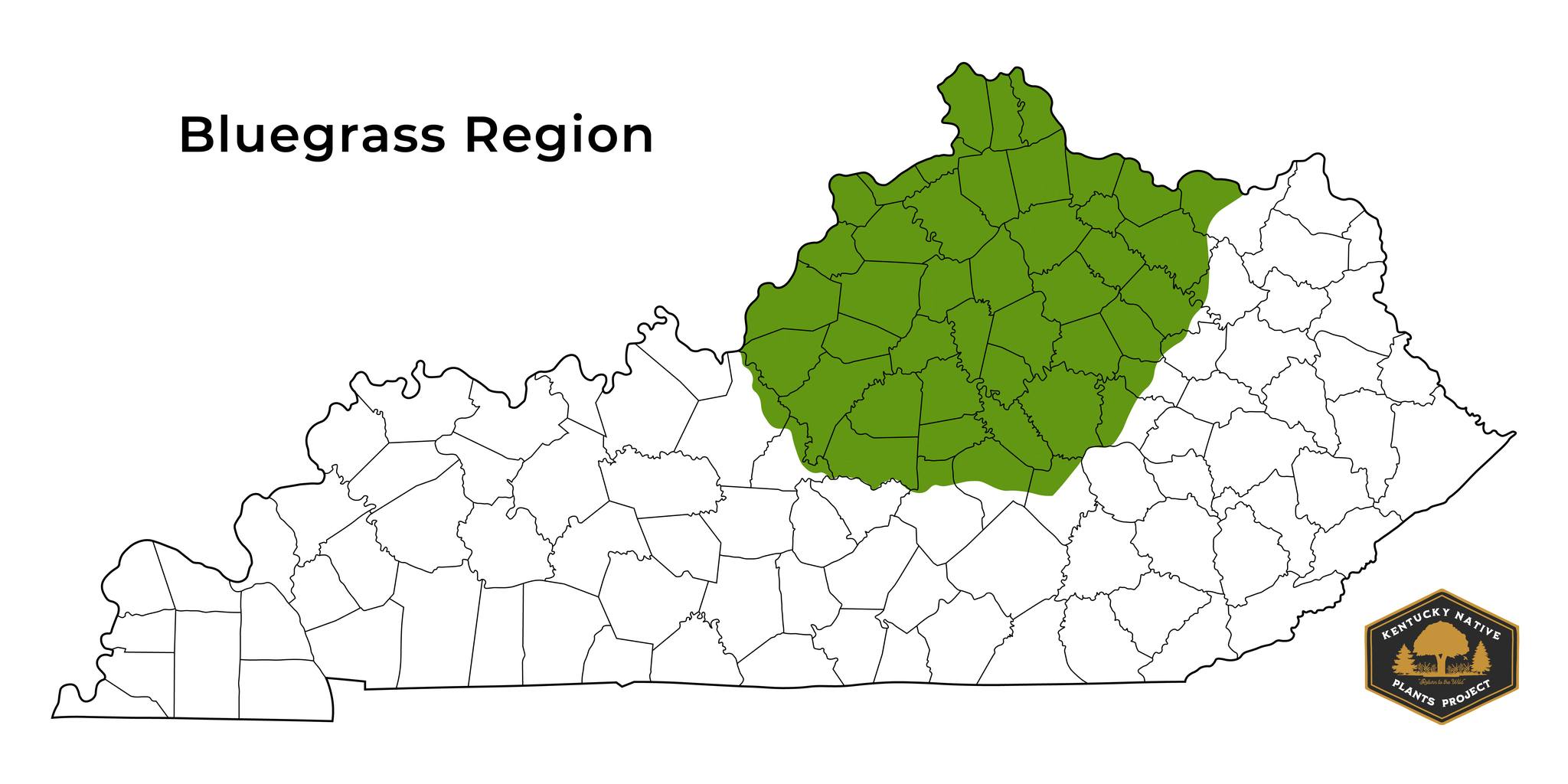
The region is known for its fertile soils, enriched with minerals from the abundance of limestone found in the area. This limestone commonly results in a basic soil pH, making it ideal for specific plants.
Historically, the Bluegrass was an open-savanna ecosystem with large trees scattered over an understory of grassland. However, after the pioneers arrived, almost every acre in the region was converted to farmland, erasing the natural landscape.
Some notable plants found in the Bluegrass Region are New England Aster (Symphyotrichum novae-angliae), Purple Giant Hyssop (Agastache scrophulariifolia), Canada Wild Rye (Elymus canadensis), Bur Oak (Quercus macrocarpa), and Blue Ash (Fraxinus quadrangulata).
The Bluegrass Region contains three sub-regions: the Inner Bluegrass, the Outer Bluegrass, and The Knobs, which we'll look at before covering the next major region.
Inner Bluegrass
The Inner Bluegrass is located in the heart of the Bluegrass Region and contains cities like Lexington, Georgetown, and Nicholasville.
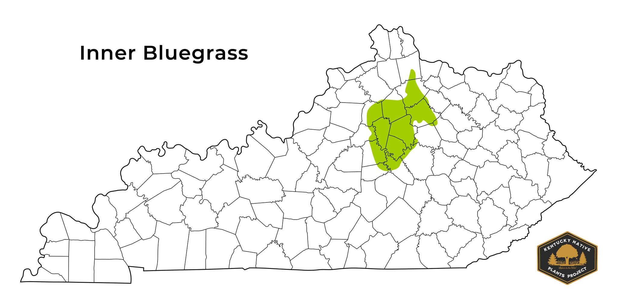
The region is known for its gently rolling hills and relatively flat land, which came from the slow weathering of its thick limestone bedrock. These conditions, and its fertile soil, have created the perfect conditions for horse breeding, which the region is famous for.
Some notable plants found in the Inner Bluegrass are Kentucky Clover (Trifolium kentuckiense), Rock Elm (Ulmus thomasii), and Aromatic Aster (Symphyotrichum oblongifolium).
Outer Bluegrass
The Outer Bluegrass surrounds the Inner Bluegrass and is the largest of the Bluegrass sub-regions. It contains cities like Louisville, Covington, and Florence.
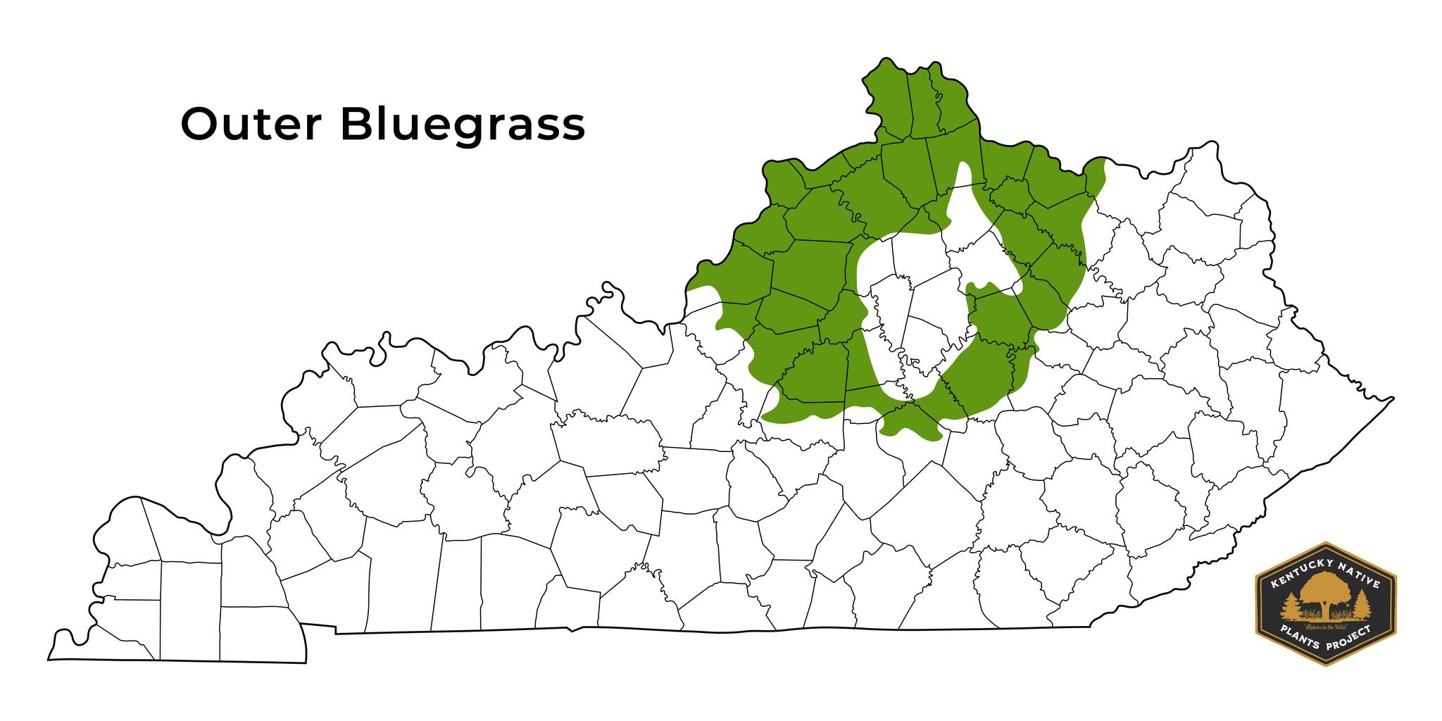
The Outer Bluegrass is similar to the Inner Bluegrass but is less flat with deeper valleys. These features are due to a mixed shale and limestone bedrock, making it more erosion-prone than the thick limestone bedrock of the Inner Bluegrass.
Some notable plants found in the Outer Bluegrass are Green Antelopehorns (Asclepias viridis), Canadian Goldenrod (Solidago Canadensis), and Pussy Willow (Salix discolor).
The Knobs
The Knobs border the Outer Bluegrass, containing cities like Berea and Shepherdsville. Bernheim Forest is also here.
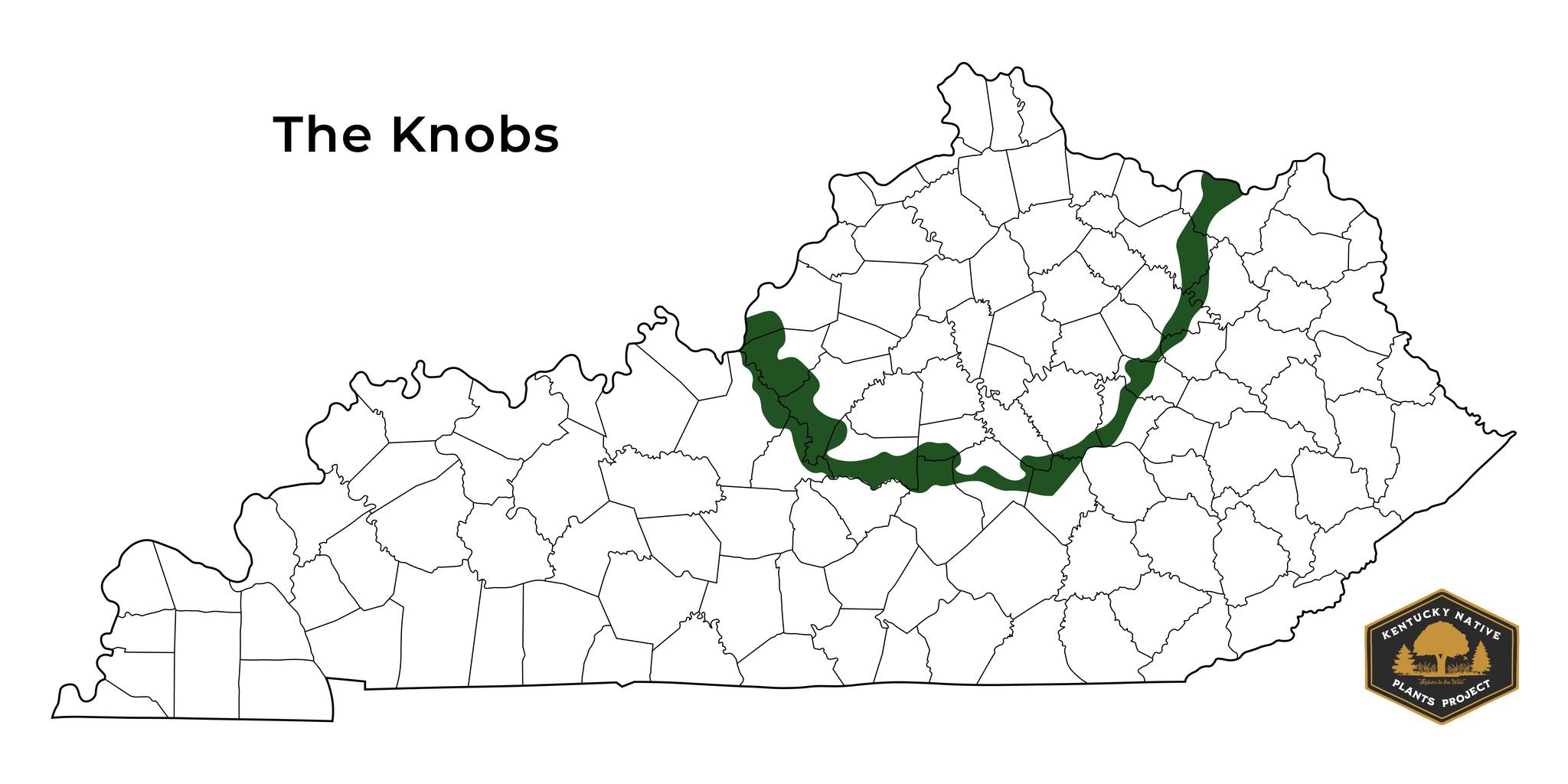
The region gets its name from the hundreds of steep-sloping, cone-shaped hills found in the area, commonly known as knobs. Deep, rich soil has accumulated in the valleys between the hills, creating valuable farmland. The Knobs are a transition zone between the Bluegrass and the surrounding regions.
Some notable plants found in The Knobs are Wild Pink (Silene caroliniana), Pale Spiked Lobelia (Lobelia spicata), and Smooth Blue Aster (Symphyotrichum laeve).
2. Appalachian Plateaus
The Appalachian Plateaus, or the Eastern Coal Fields, comprise most of eastern Kentucky and contain cities like Ashland, Middlesboro, and London. The region also includes some of the most scenic areas of Kentucky, such as Red River Gorge, Cumberland Falls, and Natural Bridge.
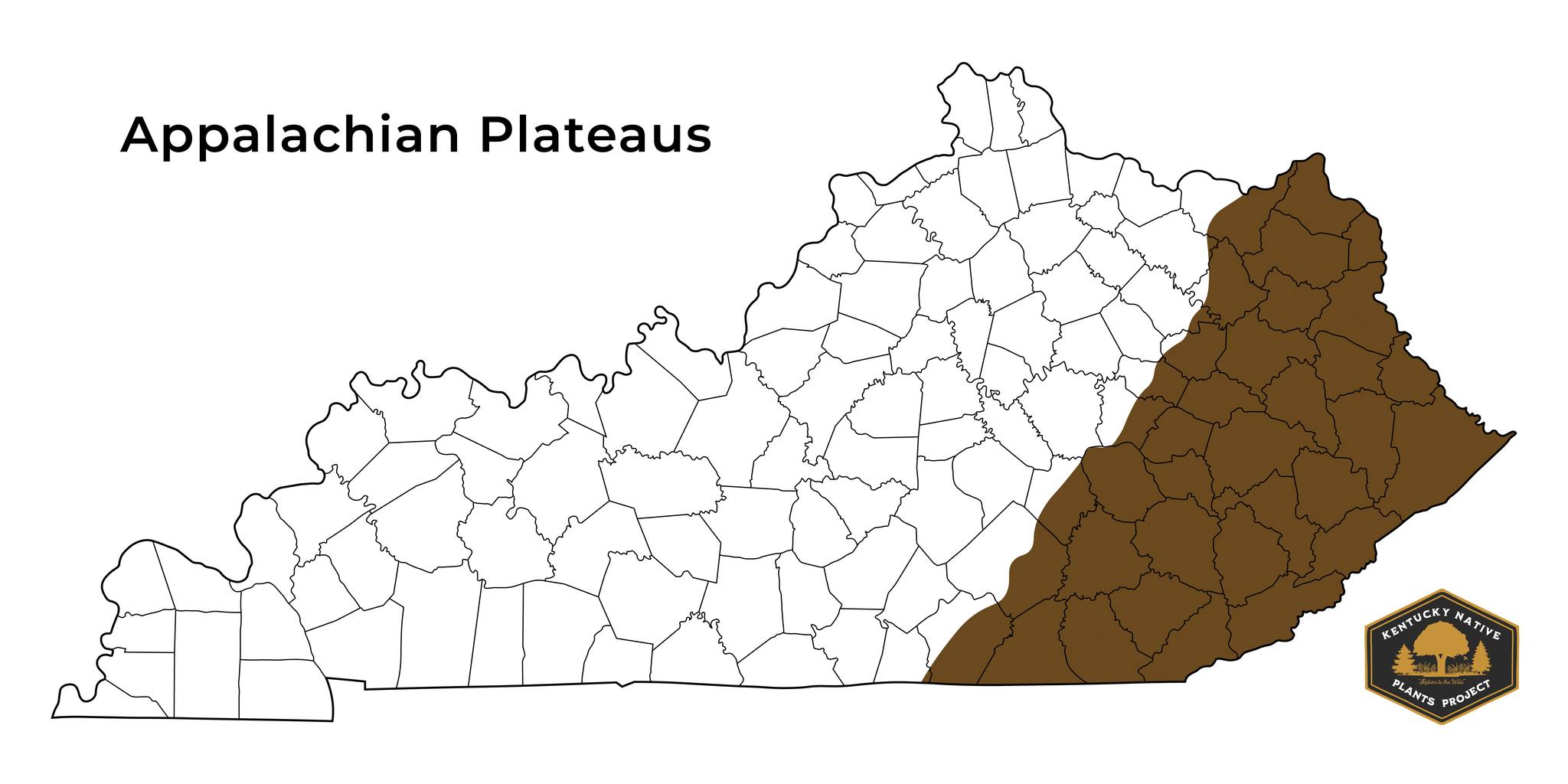
The region is known for its rugged terrain of cliffs, steeply sloping ravines, and narrow valley bottoms. The soils here are slightly acidic from an abundance of sandstone and shale. Still, neutral pH soils are also present from pockets of limestone. This assortment of pH allows for a wide diversity of native plants.
Historically, the region was a mixed forest with a vast diversity of trees. However, because of the heavy logging practices of the 1800s, the chestnut blight of the early 1900s, and coal mining practices, little remains of what was originally there.
Some notable plants found in the Appalachian Plateaus are Downy Goldenrod (Solidago puberula), Red Trillium (Trillium erectum), Appalachian Sedge (Carex appalachica), Pinxter Flower (Rhododendron periclymenoides), and Eastern White Pine (Pinus strobus).
The Appalachian Plateaus contain three sub-regions: the Outer Appalachians, the Central Appalachians, and the Cumberland Mountains, which we'll examine before covering the next major region.
Outer Appalachians
The Outer Appalachians run along the western edge of the Appalachian Plateaus and contain cities like Moorehead, London, and Ashland. The majority of the Daniel Boone National Forest is also here.
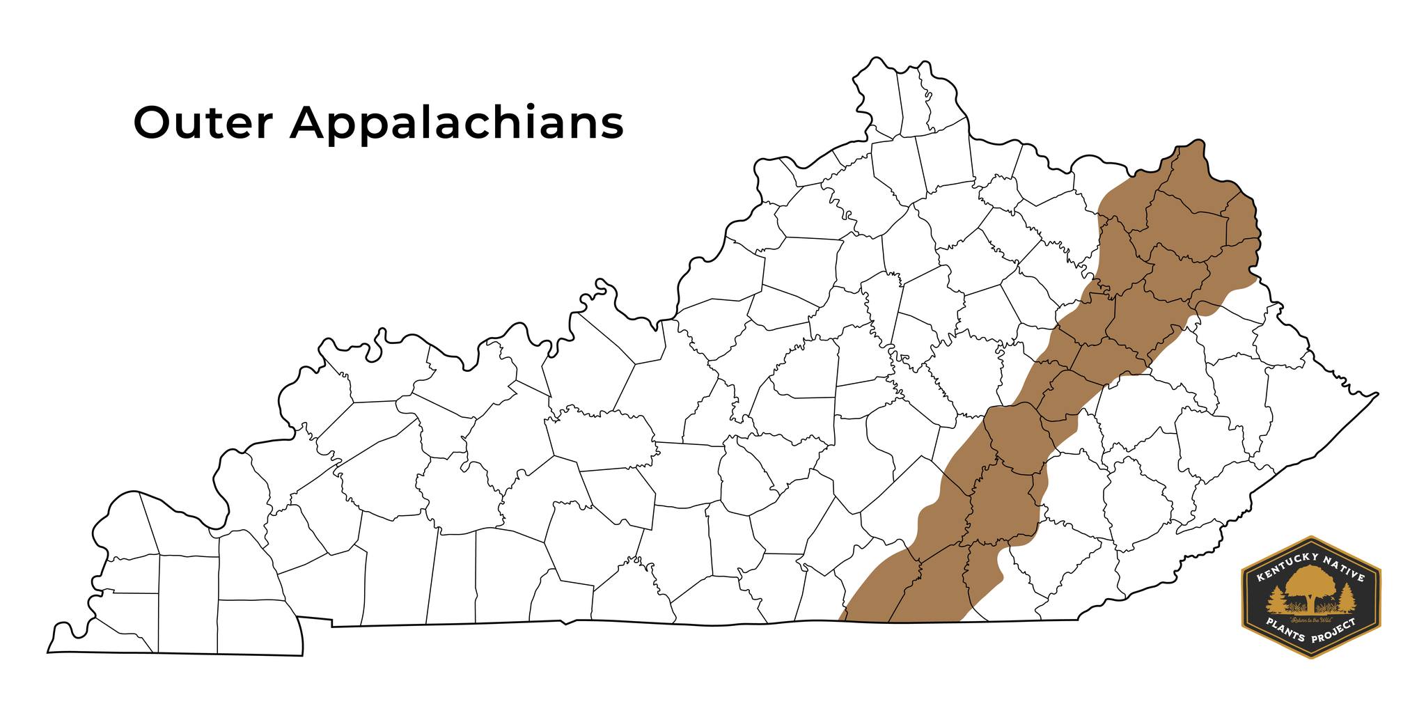
The Outer Appalachians are a diverse region featuring multiple areas with distinct topography and geology. Plant life is also unique in the area, as it commonly contains species from its east and west, acting as an intersection between neighboring regions. The region is primarily forested and has diverse landscapes of hills, ridges, and low mountains. Still, in general, it's the least rugged of the Appalachian Plateaus' sub-regions.
Some notable plants found in the Outer Appalachians are Smallhead Blazing Star (Liatris microcephala), Maryland Golden-Aster (Chrysopsis mariana), and Carolina Sweetshrub (Calycanthus floridus).
Central Appalachians
The Central Appalachians comprise the heart of the Appalachian Plateaus and contain cities like Paintsville, Pikeville, and Hazard. The Redbird District of the Daniel Boone National Forest is also here.
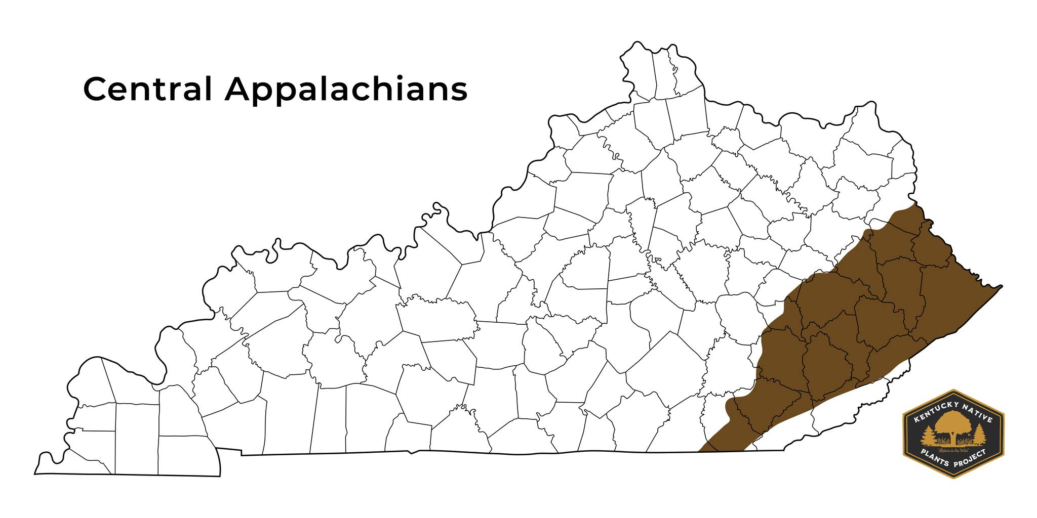
The region has more rugged terrain and extensive forests than the Outer Appalachians. Because of its narrow ridges, deep coves, and narrow valleys, access to the sun can vary greatly, which makes the plant communities variable from one area to another. The underlying rock consists of shale, siltstone, sandstone, and coal.
Some notable plants found in the Central Appalachians are Goatsbeard (Aruncus dioicus), Yellow Buckeye (Aesculus flava), and Shortleaf Pine (Pinus echinata).
Cumberland Mountains
The Cumberland Mountains sit at the southeastern edge of the Appalachian Plateaus and contain cities like Middlesboro, Cumberland, and Harlan. Kentucky's highest elevation lies here at Big Black Mountain, which sits 4,145 ft above sea level.
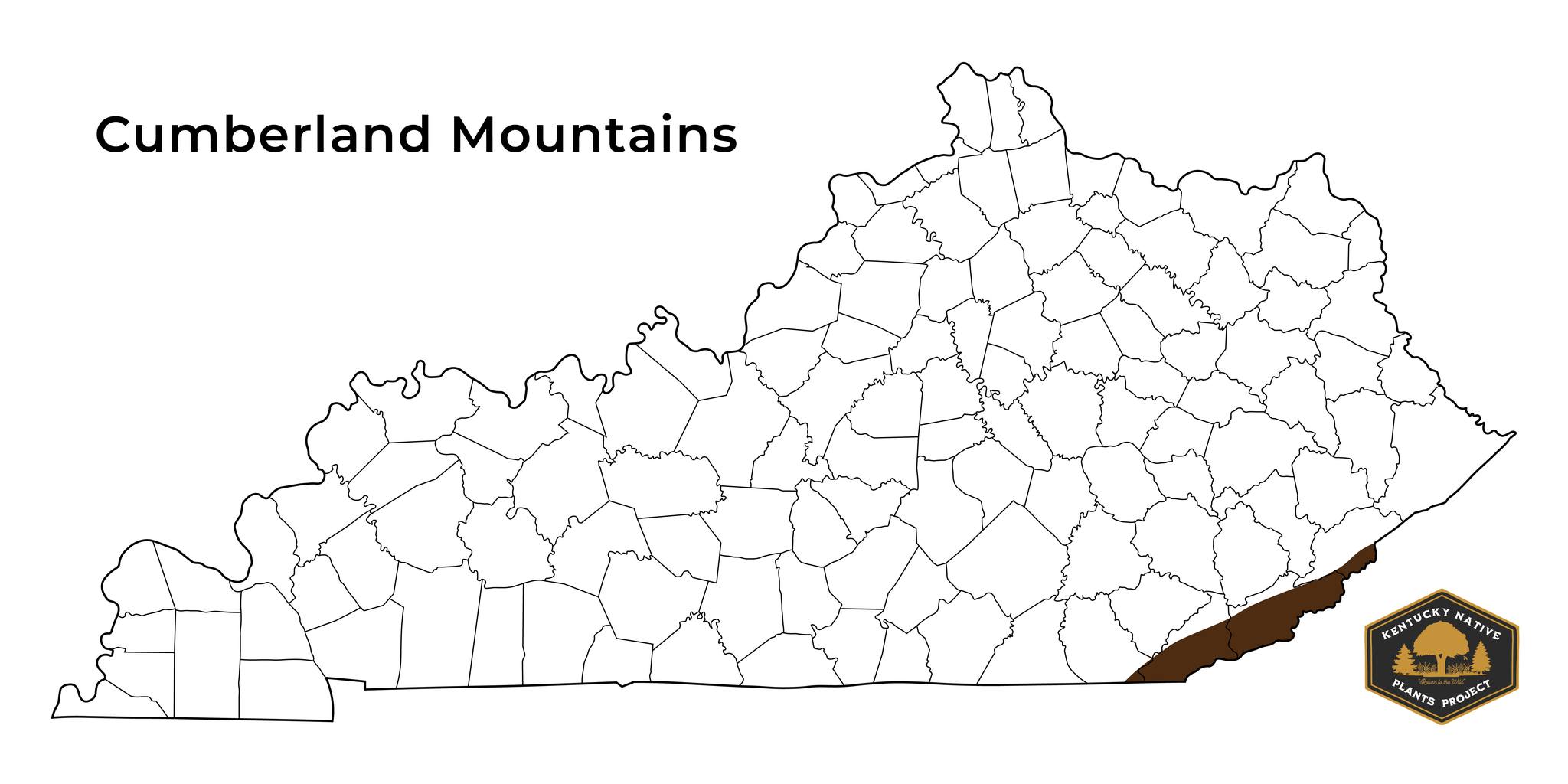
The region's steep terrain allows for shading and pockets of cool, moist habitat. This shading, and the high elevation, allow for plant communities unique to the region. Soils here are generally rich and slightly acidic.
In the past, the Cumberland Mountains were part of some of the most diverse forests of the Eastern US. Unfortunately, human activity has dramatically impacted this.
Some notable plants found in the Cumberland Mountains are Mountain Holly (Ilex montana), Dwarf Chinkapin Oak (Quercus prinoides), and Striped Maple (Acer pensylvanicum).
3. Mississippian Plateau
The Mississippian Plateau, also known as the Pennyroyal or Pennyrile Region, is in south-central and western Kentucky. It contains cities like Bowling Green, Elizabethtown, and Somerset. The name Pennyroyal comes from a European mint-like plant introduced to the area.
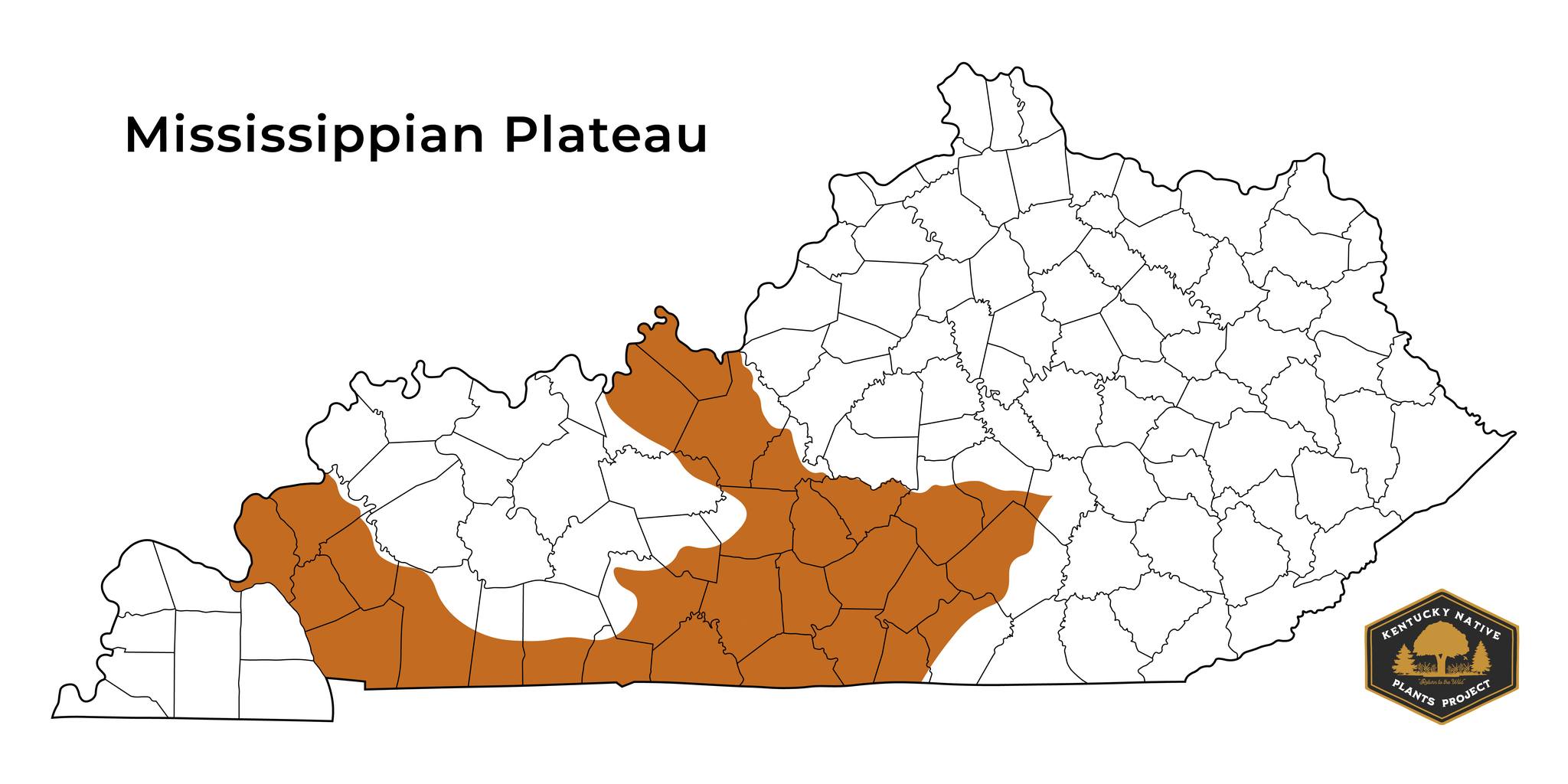
The region is a limestone plain where groundwater has slowly eroded over time, creating thousands of caverns, springs, disappearing streams, and sinkholes. Its deep, rich soil has made it a hub for agricultural farming, greatly diminishing the large areas of prairie habitat it historically contained.
Some notable plants found in the Mississippian Plateau are Tall Green Milkweed (Asclepias hirtella), Clustered Mountainmint (Pycnanthemum muticum), Royal Catchfly (Silene regia), Tansy Rosinweed (Silphium pinnatifidum), and Hairawn Muhly (Muhlenbergia capillaris).
The Mississippian Plateau contains two sub-regions: the Eastern Mississippian Plateau and the Western Mississippian Plateau, which we'll look at before covering the next major region.
Eastern Mississippian Plateau
The Eastern Mississippian Plateau is in south-central Kentucky and contains cities like Campbellsville, Columbia, and Somerset. Lake Cumberland, among other lakes, is found in the region.
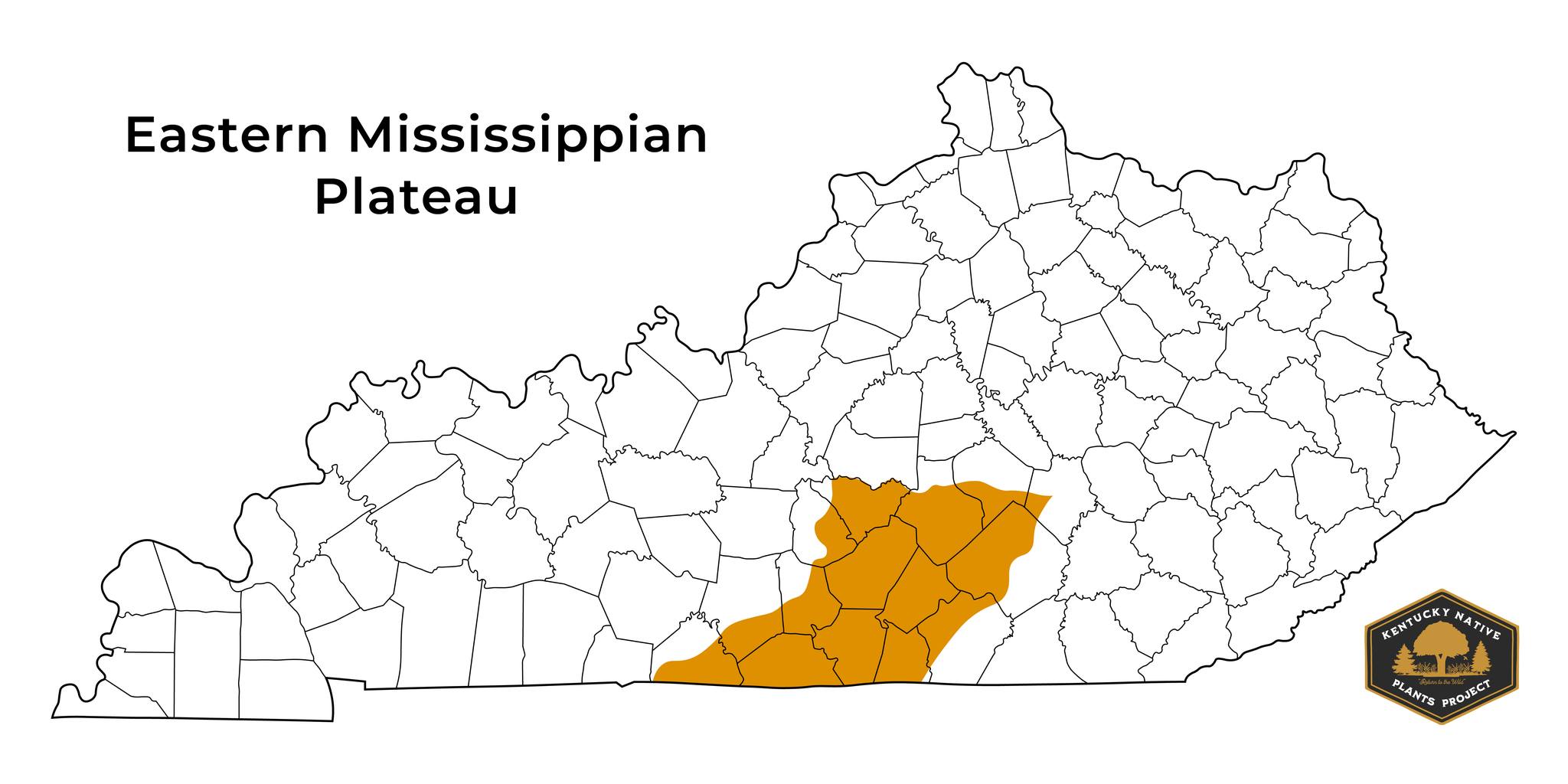
While not as rugged as the Appalachian Plateaus, it does feature steep ridges and more hills compared to the Western Mississippian Plateau. Various lakes lie in the region, where water has accumulated in the wide bottomlands between the taller topography. Soil tends to be more fertile in these bottomlands. The region is also more forested than its western counterpart.
Some notable plants found in the Eastern Mississippian Plateau are Yellow Wakerobin (Trillium luteum), Carolina Climbing-Milkweed (Matelea carolinensis), and Showy Goldenrod (Solidago speciosa).
Western Mississippian Plateau
The Western Mississippian Plateau encircles the Shawnee Hills and contains cities like Bowling Green, Elizabethtown, and Hopkinsville. The majority of Mammoth Cave National Park is also in the region. It is the only national park located in Kentucky.
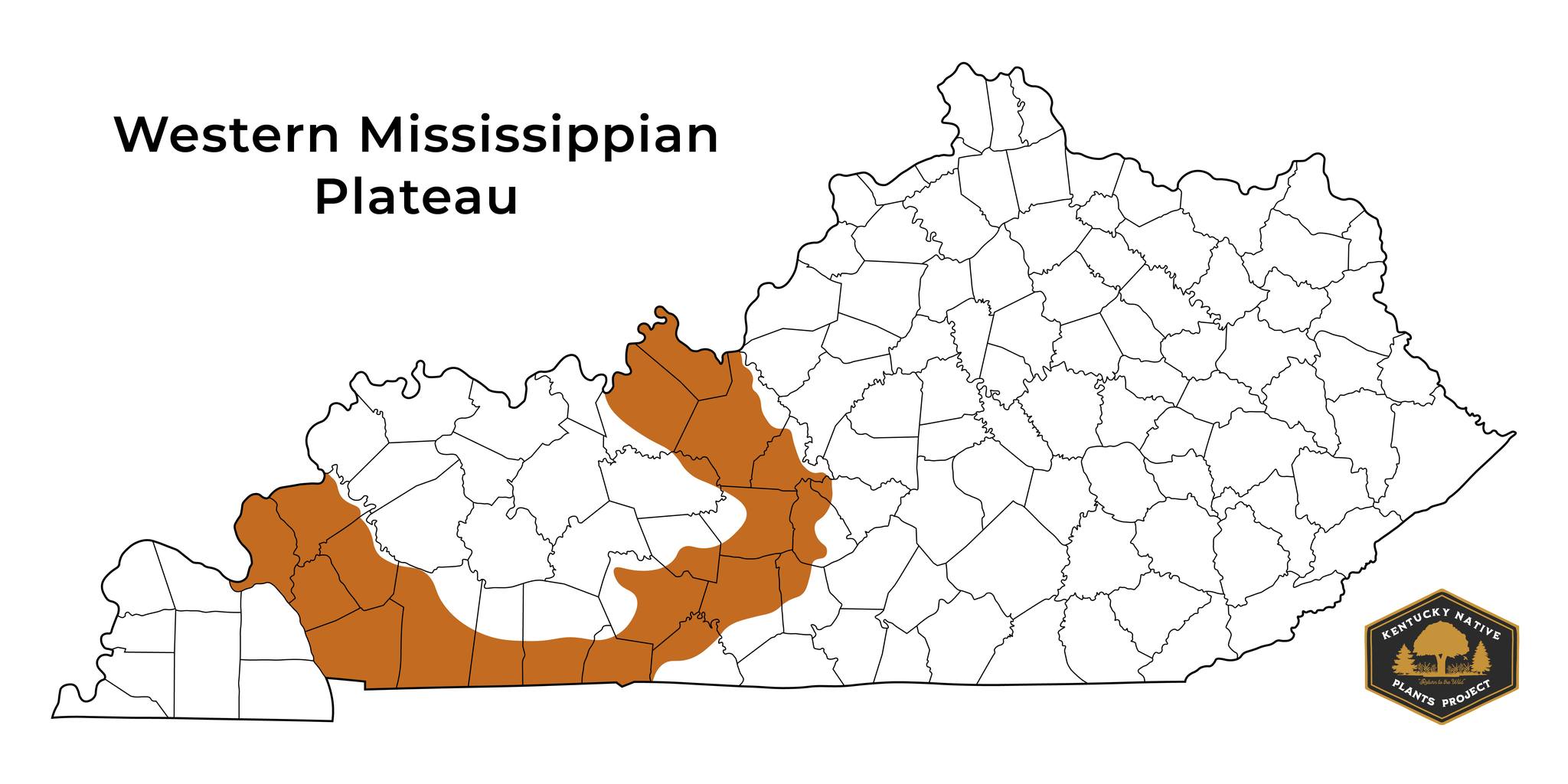
The region is more flat than the Eastern Mississippian Plateau and contains more prairie-specific, sun-loving plants. Many unique prairie plants of Kentucky are only native to this region. Sadly, very little of the original prairie that once stood here remains due to converting the land to farming, especially in the southern areas.
Some notable plants found in the Western Mississippian Plateau are Purple Prairie Clover (Dalea purpurea), Limestone Fameflower (Phemeranthus calcaricus), and Prairie Dropseed (Sporobolus heterolepis).
4. Shawnee Hills
The Shawnee Hills, also known as the Western Coal Fields, are located in northwestern Kentucky and contain cities like Owensboro, Henderson, and Madisonville. Green River and part of Mammoth Cave National Park are also in the region.
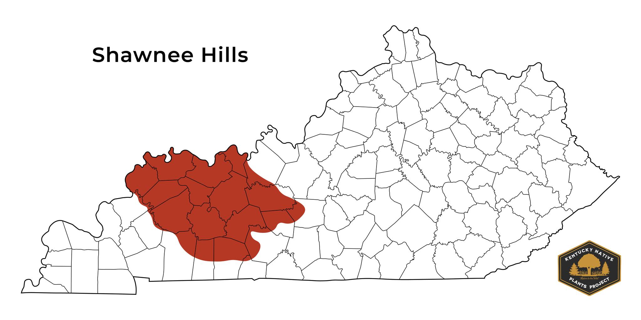
The region contains swampy areas along the flood plains of the Green River and oak-hickory forests dispersed through the low hills found upland. The swampy areas typically have acidic, infertile soil. In contrast, the upland areas commonly have more fertility from sediment blown in by the wind.
Some notable plants found in the Shawnee Hills are Wild Quinine (Parthenium integrifolium), Prairie Rosinweed (Silphium integrifolium), Woodland Pinkroot (Spigelia marilandica), Pecan (Carya illinoinensis), and Overcup Oak (Quercus lyrata).
5. Jackson Purchase
The Jackson Purchase, also known as the Mississippi Embayment, is located along the Mississippi River on the western edge of Kentucky. It contains cities like Paducah, Murray, and Mayfield.
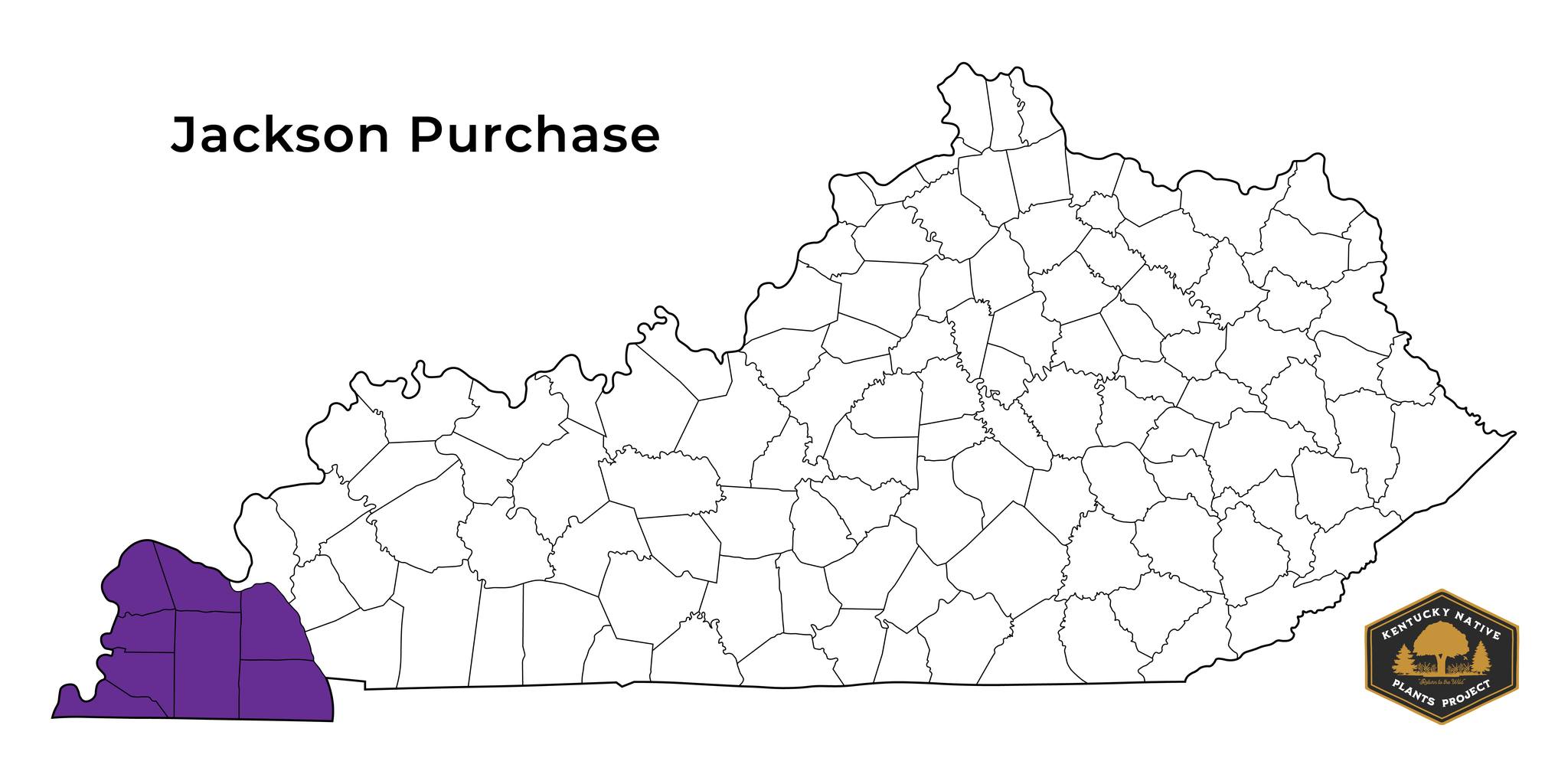
The region is relatively flat, with low plains, and is a wetland area unique to Kentucky. It contains several ponds, river bottoms, sloughs, and swamps. It also includes the state's lowest elevation, only 260 ft above sea level. The soils are generally clays and sands deposited from past flooding.
Like many of our regions, it's been largely cleared for human development, leaving little of what was originally there. However, a small wetland area remains protected in Hickman County, named Murphy's Pond, owned and managed by Murray State University.
Some notable plants found in the Jackson Purchase are Snow Squarestem (Melanthera nivea), Eastern Bluestar (Amsonia tabernaemontana), Leafy Blue Flag (Iris brevicaulis), Palm Sedge (Carex muskingumensis), and Baldcypress (Taxodium distichum).
Preserving Our Ecological Regions
Kentucky is home to multiple ecological regions, each with distinct characteristics and species of plants.
Understanding and protecting your ecoregion can ensure a healthy and thriving natural environment for all the species that call this state home.
Check for your region in the "Native Range" section of the plant infographics we include in every plant list article. It will help you select the plants well-suited for your local environment.
Leave a comment with which ecoregion you're from!